Article featuring the project.
Rebecca Borges
Other projects
31 Oct 2022
Making Space for Conservation: How Relationships and Perceptions Can Guide Science Communication and Zoning for Ecosystem Services on the Amazon Coast
Using participatory mapping, this project aims to generate socio-ecological information for zoning strategies and allow for effective spatial management.
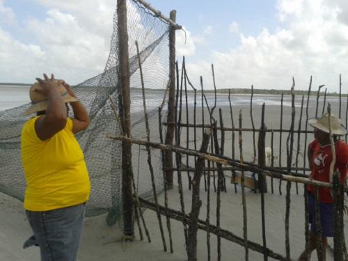
Predatory fishing trap Fuzurca.
Mangroves in north Brazil are home to traditional extractive populations. In order to promote the sustainable use of resources, the concept of Extractive Reserves (with the Portuguese acronym RESEX, IUCN category VI) has been formulated in Brazil as protected areas that have a strong focus on the sustainability natural resources, based on a responsible interaction between users and the environment, from where their resources mainly come. According to the Brazilian national law that regulates the creation and functioning of all protected areas, a RESEX corresponds to an ‘area used by traditional extractive populations, whose livelihood is based on extractivism and, complementarily, on subsistence agriculture and on small-scale animal farming.

Brochure.
Due to population growth, urbanization and poorly planned development, political and territorial disputes are a growing threat in the region. Besides, most users of the two marine protected areas are largely unaware of the role of these reserves, and what exactly they represent. Conservation research effort in the region has three main deficiencies that this project will address: 1) lack of spatially-explicit ecological data to support spatial planning initiatives; 2) lack of involvement of local actors beyond traditionally-active leaders; and 3) lack of largely-publicized research results, which are directly transmitted to the local populations, using easily understandable material and more direct interaction techniques
Using participatory mapping methods with local actors, this project will generate socio-ecological information for zoning strategies and facilitate effective management, aiming to 1) better allocate the extraction of forest and fisheries products, which are important income sources for the local communities, and 2) attenuate territorial conflicts among resource users. Initial mapping effort will be followed by awareness campaigns and direct consultations through interviews and workshops. Outreach material, including maps, brochures and videos, will help raise awareness about the current zoning and provide a discussion platform for questions and suggestions from local actors.
The present project will create awareness material and, therefore, facilitate stakeholder engagement in the development and revision of the zoning strategies for the two protected areas. This interactive process is expected to produce recommendations for zoning with large acceptance by local users and allow for higher compliance.