Article featuring the project.
Factors Affecting Distribution and Habitat Association of Red Panda in Bhojpur District, Nepal
14 Aug 2017 Bhojpur, Nepal, Indian Sub-continent Carnivores | Communities | Mammals
The project aims to provide baseline information on the status, distribution and threats to Red Panda in Bhojpur districts.
Create a Geographical Information System (GIS) maps to compile biological and environmental related information regarding species and their habitats.
To empower the local government bodies and community group with science based survey techniques, educates them in the issues of species conservation and motivates them to sustain the initiative by building ownership of the species and their habitats.
To conduct different Awareness and environmental education activities in schools and communities hoping to address species conservation issues for better understanding of nature and wildlife.
To encourage the local community for bio-briquette production through training in order to decrease their dependency on forest resources for firewood.
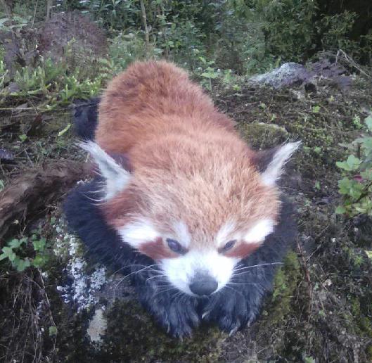
The Red Panda (Ailurus fulgens) is classified as an endangered species by the IUCN and in Nepal as a protected species under the National Park and Wildlife Conservation Act 1973. Few studies have been conducted outside the PAs focusing this species, which correspond to regions where more than 62% of Red Panda potential habitats remains available. Being contiguous with Makalu-Barun National Park, Bhojpur supposed to harbor a population of Red Panda. There is, however, scanty information on this species status and distribution in the region, which are requisite to develop conservation action at landscape/regional scales. Due to poverty and low level of awareness, local people are unaware about species ecological importance, its legal protection and need for habitat conservation. So they are heavily dependent upon forest resources for their livelihood.
The project aims to provide the baseline information on the status and distribution of red panda in Bhojpur district. The creation of up-to-dated GIS maps will provide valuable information on species occurrence, habitat distribution and areas of specific habitat degradation which are essential for concern authorities to formulate effective conservation policies and strategies. Moreover, the project also target to involve community toward the conservation initiatives of red panda and its habitats. Such conservation initiative is climacteric to build a sense of ownership of local communities in species conservation and foundation to the conservation effort. Such that local stakeholders will be empowered with red panda survey and monitoring based capacity building program (identify the sign of red panda, learn to use GPS, and data recording). This will foster local persons as conservation actors (citizen scientists) and wildlife monitors to ensure sustainable monitoring and conservation actions in the future.
Furthermore, community and school based outreach programs will aware local community regarding legal provision concerning conservation of red panda, species conservation importance and need for habitat conservation. This develops positive changes on prevailing attitudes regarding species and habitat conservation which results to reduce deforestation, species illegal trade and poaching by assuring their stable and lasting participation in conservation.
Article featuring the project.
Factors Affecting Distribution and Habitat Association of Red Panda in Bhojpur District, Nepal