Voon-Ching Lim
This project seeks to (i) assess the current social, economic and environmental conditions of TMP and (ii) understand how the communities and businesses are using and planned to utilise the marine ecosystems. The resulted findings would enhance the existing integrated management plan of TMP. This project will map the marine habitats in TMP and the services they provided as well as the anthropogenic threats through community mapping and Photovoice. In addition, this project will be a platform for the communities to voice their concerns, hence instilling the sense of ownership within them and empowering them to protect their homeland.

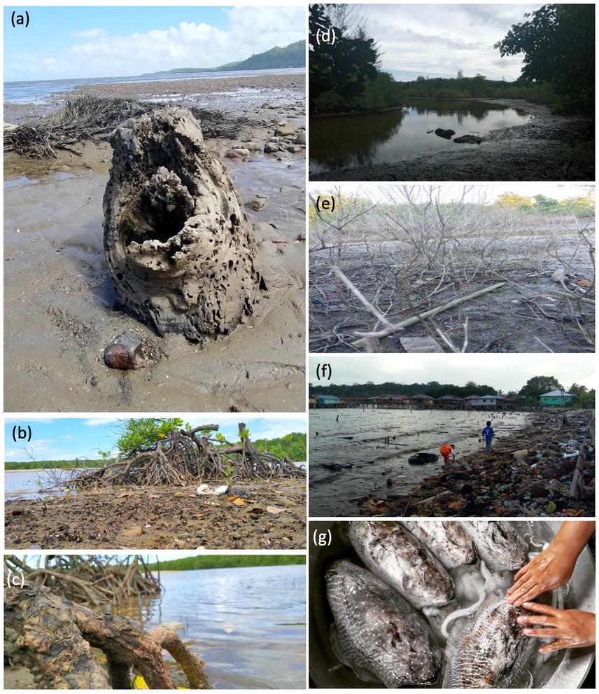
Photographs portraying environmental aspects of participants’ life associated with cultural, provisioning, regulating and supporting services. (See below for detail).
Understanding the supply and demand of ecosystem services within a marine protected area is crucial for developing an integrated management plan. Ecosystem service supply is the capability of an area to provide ecosystem goods and services within a given time period, whereas ecosystem service demand is the ecosystem goods and services consumed and used in an area over a time period. High level of demand exceeding level of supply in an area may lead to unsustainable use of ecosystem goods and services.
As the residents of the habitats and hence the primary users of ecosystem services, local communities can provide insights into socio-ecological situations in a particular area through their observation and experience. Such local knowledge could facilitate the identification of socio-economic situations which contributed to the unsustainable use of marine resources, which in return could assist the development and betterment of management plans for the area. One way to obtain the local knowledge is through community-partnered participatory research, where the local communities are involved in the research and given an equal share in decision-making. Moreover, participatory approach can be a powerful educational tool which could instil pride and interest in the local communities to protect their homeland.
This project will produce an overview of socio-ecological systems in Tun Mustapha Park from the local communities’ perspectives. The resulted findings will be presented to relevant stakeholders including local communities, businessmen, and state government. The data from this project will facilitate the development of informative models and planning tools which could support sustainable marine resource use and improve the understanding of relationships between marine environment and well-being of coastal communities. At the end of this project, a photo exhibition will be organised to serve as a platform for the participants to showcase their photography skills and promote their homeland, hence instilling the sense of pride and ownership among the participants who are the residents of the marine protected area. Coffee-table books will be produced to generate additional income for the participants. Publication in international journal is also expected.
Photo: Photographs portraying environmental aspects of participants’ life associated with cultural, provisioning, regulating and supporting services.
(a) Mangrove stumps were washed ashore during wet season and can be used for craft. (b) Unregulated cutting and pollution could cause the extinction of mangrove trees. (c) Unique looking roots of mangrove trees could strengthen the soil structure and prevent sea erosion at shore. (d) This river at a mangrove was experiencing erosion and becoming shallower, hence causing population decline of its inhabitants. (e) The river at this mangrove was drying up and have poor water flow, causing the trees unable to grow and hence died. (f) The poor waste disposal system had caused the accumulation of rubbish at this shore, causing discomfort to the villagers. (g) Cuttlefish is a local favourite seafood which used to be abundant in coral reefs surrounding the Banggi Island but is rarely caught nowadays due to uncontrolled fishing activities.