Neethi Mahesh
Other projects
Technology based river monitoring platforms will enable monitoring and reporting of river ecosystems, facilitating a voice for citizens by means of water quality testing, landscape monitoring and observations on flora and fauna, along with visual media documentation. The philosophy and science of it emphasises on shared learning, to better understand and respect the lifelines that support our very existence.
Replication of the spatial ecology study with population of Mahseer fish species in the Cauvery Wildlife Sanctuary, the largest protected river stretch in Karnataka state, will help bridge the knowledge gap on ecological and spatial requirements, essential for river habitat conservation.
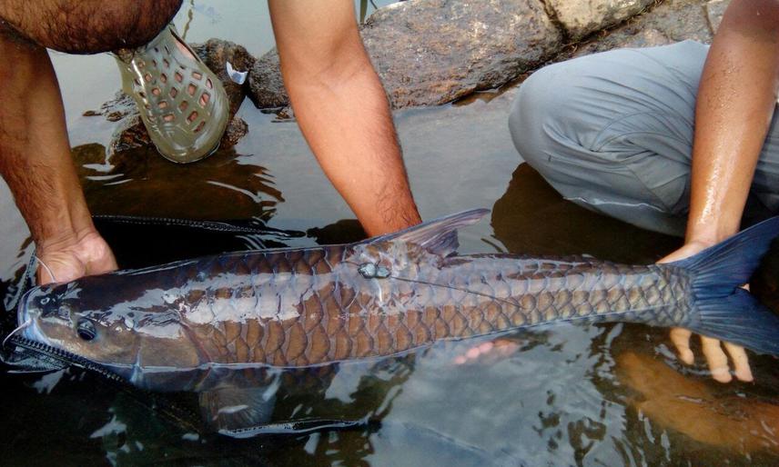
Mahseer with external radio tag.
Citizen science platform for river conservation:
A tried and tested river monitoring model in Coorg District, is now ready to be launched into a citizen centric platform to enable bringing rivers and their complex interrelationships to the forefront. This approach takes into consideration a broad spectrum of activities one can engage in, contributing to research and monitoring efforts, which can lead to location specific solutions which are more practical in nature. Indigenous knowledge, such as the availability of fish species, for instance, and how to catch them, has instant power in connecting people to what they value about river resources. The sightings of otters, crocodiles, seasonal and migratory bird species, for example, can also tell us how healthy the river ecosystem is, indicating good health. Delving deeper into the process, monitoring water quality can help identify sources of pollution and additionally aid with creating a network of individuals and groups keeping track of waterways at regular intervals, along its course. This broadens the scope of public involvement, providing a democratic platform to showcase concerns and meet challenges, which are otherwise difficult to address at a river basin scale.
Continued efforts to consolidate baseline information:
The first of its kind, pilot radio telemetry study carried out with Mahseer fish in the catchment area of the Cauvery river, identified the need to continue spatial ecology and movement studies in a contiguous protected area, existing under the Cauvery Wildlife Sanctuary. With over 40 years of conservation of Mahseer, this location has the last stronghold of critically endangered Humpback Mahseer, in the Cauvery. Based on various studies and reports, including the telemetry study, the Karnataka Forest Department are encouraging and supporting scientists and NGO groups, to help secure the future for increasingly threatened river habitats with critical focus on Mahseer.