Manase Elisa Pallangyo
Other projects
24 Aug 2018
The Impact of Water Abstraction and Changes in Surface Water Availability on Ecological Integrity the Arusha-Kilimanjaro Ecosystem, Tanzania
26 Aug 2021
The Impact of Surface Water Availability and Quality on Physiological Stress in Large Mammals in the West Kilimanjaro Ecosystem, Tanzania
Increasing human population and associated freshwater demands, particularly for irrigation farming, pose a major threat to wild animal welfare. This study will address one of the fundamental flaws in Tanzania water resources management where lack of data leads to un-sustainable water resource exploitation that severely impacts the well-being of wild animals. It will identify how much water is used by human communities and at what cost to the downstream ecology of one of the most wildlife rich areas of Africa. The study will map the spatial and temporal distribution of surface water in the west-Kilimanjaro ecosystem, provide an assessment of the quality and quantity of such water, and assess the impact of changes in surface water on the wild herbivores. Such information is an essential prerequisite to the development of sustainable water resources management for wildlife and the local communities.
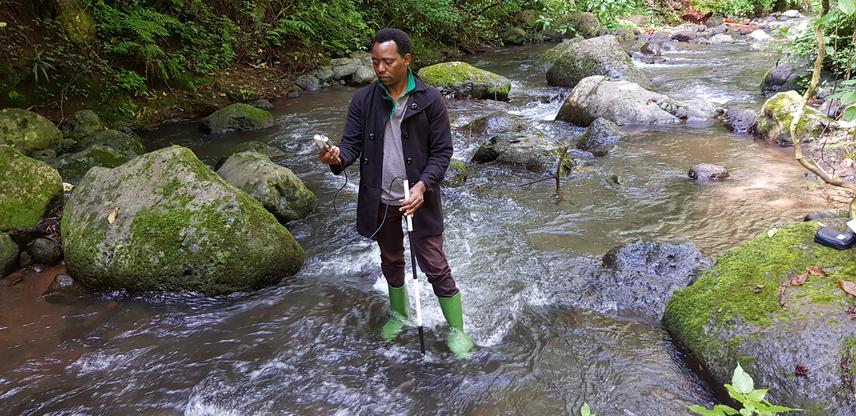
2Measuring flow rates in Simba river in the West Kilimanjaro ecosystem.
This project is carried out in the West-Kilimanjaro area which is part of the larger Arusha-Kilimanjaro ecosystem, a wildlife-rich area in the northern Tanzania. It consists of arid land situated between Arusha and Kilimanjaro national parks and irrigated by rivers from the two parks. The area consists of several protected and non-protected areas including NARCO and Ndarakwai ranches, Enduimet wildlife management area and two potential wildlife corridors; Kisimiri (currently blocked by expanding human settlements and farming), and Kitendeni, that respectively link Arusha national park to the West Kilimanjaro area, and Kilimanjaro national park to Amboseli national park in Kenya. The main sources of water are the perennial Ngarenanyuki and Simba rivers that respectively drain Mount Meru (Arusha national park), and Mount Kilimanjaro (Kilimanjaro national park). The rivers are excessively abstracted for beans and vegetable irrigation farming and also supply water for domestic, livestock and wild animal use. The study area contains a number of charismatic wildlife species including elephant, buffaloe, wildebeest, zebra, gazelle, giraffe, lesser kudu, striped hyena and leopard.
Preliminary work has highlighted the potential for critical impact of water abstraction on herbivores in the low land dry areas of west Kilimanjaro. It is also apparent that the wildlife is particularly vulnerable during the dry season when the area is even more arid, and the animals depend on the few remaining water access points. Unfortunately, upstream dry season irrigation farming over-abstracts water from the key water sources, the Ngarenanyuki and Simba rivers originating respectively from Arusha and Kilimanjaro National Parks, causing deprivation of water for people, wild animals and livestock in the biodiversity-rich downstream areas. To establish a reliable trend and explanation of the way changes in surface water is affecting the biodiversity, adequate spatial and temporal data must be collected. Here, I plan to extend the assessment on how changes in surface water and river abstraction affect wild herbivores abundance and distribution in the dry areas so as to generate essential information for improving water resources management for the welfare of both wild animals, livestock and the human population.
The study will provide the evidence for the impact of water abstraction on the wild herbivores through:
i)mapping of the spatial and temporal distribution of surface water in the west-Kilimanjaro ecosystem
ii) providing an assessment of the quality and quantity of such water,
iii) assessing herbivores abundance, distribution and space use in relation to available surface water.
These results will be supported by a spatial evaluation of changes in surface water over time in this landscape using remote sensing. This will be important information for management of the wildlife protected areas, and the surrounding unprotected areas, in providing solid science-based data for informed management.