Lucy Perera
The effects of habitat destruction on tropical large carnivores and their prey has been well documented. However, we still have a poor understanding of how cryptic disturbances, such as hunting and tourism, impacts carnivores and other large vertebrates. This study aims to assess: 1) how wildlife communities change across a disturbance gradient; 2) the relation of these changes with the spatial distribution of jaguars and whether jaguars are a good indicator of wildlife communities’ integrity. The results from this study will also provide 3) guidelines for effective sampling design for both vertebrate communities and jaguar monitoring and 4) evidence to assess the effectiveness of Community-based Forest Concessions for the sustainable use and conservation of wildlife. Tropical forest management and the balance of wildlife and human needs will benefit from an understanding of the spatial extent of wildlife responses to cryptic disturbances and the spatial requirements of actions to ameliorate them.
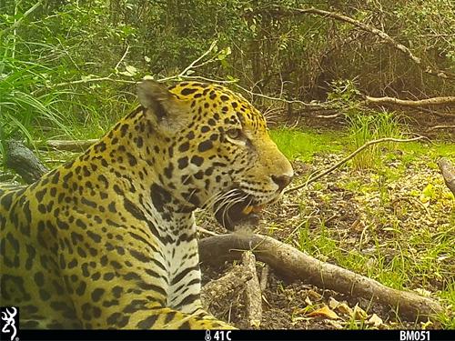
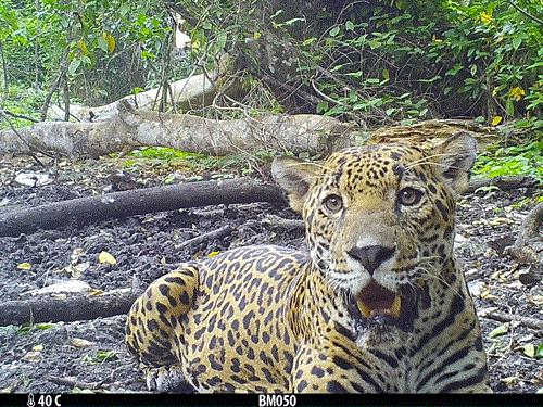
Jaguar.
The Maya Biosphere Reserve is (MBR) located in northern Guatemala covering an area of 2.1 million hectares. My study area comprises areas with well-preserved forest cover but with a gradient of protection underneath it. I will be working in Uaxactun Forest Concession, Mirador-Rio Azul National Park and Dos Lagunas Wildlife preserve. Unpaved roads facilitate the access to these areas for tourism and forest products harvest up to a point into Uaxactun. The access to Mirador National Park is therefore limited and is reached by tourists only by walking trails. This creates a gradient of human access from Tikal National Park with a great influx of tourist, passing by Uaxactun with access by community members, to Mirador NP with access only to a few intrepid tourists willing to trek a long distance. This gradient of disturbances, cryptic to remote sensing, will be the main object of study.
Field surveys will be aimed to generate data on 1) the distribution of vertebrates, and 2) the distribution and density of jaguars across a gradient of cryptic disturbances. I will assess wildlife communities through point count surveys for arboreal species and camera trapping surveys for terrestrial species. To study the structure of terrestrial vertebrate communities I will assess multispecies occupancy to understand how species’ specific occupancies and species richness overall and by functional group are affected by human disturbance. Then, I will use categories of distance to human settlements to segregate the information and calculate their “defaunation index”, (a weighted dissimilarity measure between a focal and a reference assemblage), in each of these categories as an approach to quantify and describe the change in vertebrate communities’ as result of human disturbance. For arboreal species I will follow the same analysis but apart from occupancy estimates I will also aim to estimate abundances from counts of large game birds and primates. Jaguar densities will be estimated with spatially explicit capture-recapture methods that accounts for both spatial variation in density and for modelling ecological distance in jaguar movement. To model spatial variation in jaguar density I will use spatial surrogates of hunting as well as measures of spatial variation in species richness or other relevant measure of vertebrate community assemblage. A positive relationship between jaguar density estimates and measures of wildlife community’s integrity would provide evidence on their value as indicator species of the health of Neotropical forest ecosystems.