Eugene Skorobogatov
The project aim is to reveal the status of River Otter in Kharkov region (North-eastern Ukraine) and to attract public attention to the species protection.
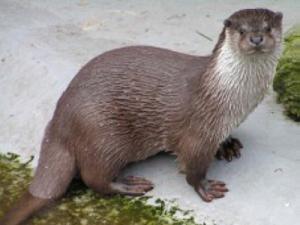
River Otter (Lutra lutra) is listed in IUCN Red List (NT), European Red List (V) and Ukrainian Red List (II). Nevertheless, the true status of Otter population in Ukraine is completely unknown as the last Otter survey was made in 1959 (Korneev, 1959).
We have noticed repeatedly that local people know little about native nature and don’t realise the necessity to protect the environment. We evidenced a lot of unlikely tales about damage by Beaver and Otter produced by local children and adults. Local mass media may get reliable environmental information only rarely and they have no ideas about the sources of such information.
As a result of the project implementation we expect getting realistic information about the distribution pattern (sites with low and high density) and the numbers of Otter population in Kharkov region for the first time for 50 years. The results of the project will be reported to general public via mass media (regional TV, papers in periodic press).
The project is a pilot phase of more ambitious undertaking. In the future we intend to organise monitoring of Otter population in Kharkov region and to undertake similar surveys and conservation actions in adjacent regions to cover a half of Ukrainian territory. All sites with high Otter numbers will be designated for special education actions.
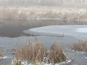
Field surveys are ongoing. The method of sampling points (Shanin 2000; Breaux et al. 2002) is used. The territory of Kharkov region was divided into 21 sub-regions (40х40 sq. km). 7 control sub-regions were chosen in different parts of the region. In each control sub-region sampling points (SP; approximately 50 per sub-region) were established on every water body classified as Otter habitat. The distance between adjacent SP is 3-5 km. Both banks are surveyed, 100 m upstream and downstream of the SP. All Otter signs were registered. The use of the method allows detecting the Otter distribution pattern at different water bodies, to estimate population size and to identify the sites with high densities.