Assam Alwash
The Iraq Upper Tigris Waterkeeper (IUTW) will perform an in-depth threat assessment of the Lesser Zab River, a major tributary of the Tigris River in northern Iraq, to document and fully characterize all threats to river habitats (fish spawning areas, river and riparian habitats), water quality and river functions. Action plans and strategies to address these threats will also be developed and the tools needed for expanding these efforts to other river basins within Iraq will be developed.
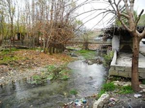
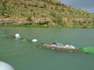
The IUTW team will conduct field surveys to identify threats and interview locals as the team travel the length of the Lesser Zab and its main tributaries. Threat identification, assessment and action planning to address these threats are not being done currently in Northern Iraq because so little information is available and there is no way to prioritize threats for action.
Prioritization and assessment of threats will then be conducted in consultation with the Kurdistan Environmental Protection and Improvement Board (KEPIB). Strategies and action plans will be developed based on each threat type and specific characteristics of the area.
NI has adopted a formal threat assessment methodology utilized by BirdLife International. This methodology is based on a set of 11 threat categories developed by the International Union for the Conservation of Nature (IUCN) and grades the key aspects of each threat (timing, scope and severity) allowing them to be prioritized and assessed over time. The assessment will be augmented to also collect additional threat specific details including but not limited to:
1. Taking locality and extent data using GPS & characterization of waste flow discharges
2. Obtaining contact information on industries involved in waste discharge to the basin
3. Obtaining contact information for local community and government stakeholders
Potential impacts from future threats will be taken into account based on interviews with regional government planners (i.e. dam construction plans within the basin). The above information will be documented in a Database/GIS application that would generate prioritized maps to aid in the assessment.
Preparation of this project began in the fall of 2011 with investigations along the river near the towns of Mawat and Dukan. The IUTW has also reached out to an important local arts and education group called SulyOn to do environmental education work in the Dukan area focused on identifying and addressing threats to the river in this area.