Michael Gilmore
This project proposes to use participatory mapping techniques as a tool to help conserve Maijuna traditional lands in the Peruvian Amazon, an area of immense biological and cultural significance.
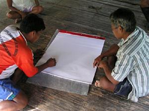
Maijuna individuals drawing a map of the Sucusari River basin.
The Maijuna, also known as the Orejón, are an Amazonian indigenous group presently found along the Sucusari, Yanayacu, and Algodón rivers of the northeastern Peruvian Amazon. There are approximately 400 Maijuna individuals living in four communities located along the above-mentioned rivers. All four Maijuna communities have received parcels of legally titled land from the Peruvian Government yet the titled land that the Maijuna have received represents a very small portion of their ancestral lands. Hence, hundreds of thousands of hectares of Maijuna traditional land remain unprotected. Today, Maijuna traditional and titled lands are under siege by illegal incursions from loggers, hunters, fishermen, and resource extractors from outside communities. In addition, the Peruvian Government has recently proposed to construct a road through Maijuna traditional and titled lands.

The Sucusari River, a culturally and biologically significant river to the Maijuna of the Peruvian Amazon.
Unfortunately, the Peruvian Government has yet to consult the Maijuna about this proposed road and its potential biological and cultural ramifications. In short, this project proposes to collaborate with the Federación de Comunidades Nativas Maijunas (FECONAMAI), a Maijuna indigenous organization, to use participatory mapping techniques as a tool to help conserve Maijuna traditional lands, an area of immense biological and cultural significance.
Participatory mapping consists of encouraging local people to produce maps of their lands, including information such as land-use data, resource distributions, and culturally significant sites, among other things. These maps ultimately represent a group’s collective cognitive map and can be used to show traditional and current occupation of lands. The maps produced during this project will ultimately be used by FECONAMAI to form the basis of official land claims against the Peruvian Government.
FECONAMAI’s ultimate goal is to work with the Regional Government of the Peruvian Amazon to have their traditional and current lands designated as an Área de Conservación Regional (Regional Conservation Area) which would formally protect and conserve approximately 300,000 hectares of lowland Amazonian rain forest.