Cyrus Mutunga Kavwele
The project aims to understand bush encroachment in savannah landscapes and it implications on species diversity and habitat use.
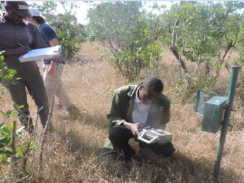
© Nickson Ndiema
Savannas cover nearly 20% of the total land mass supporting an array of both plants and animals. However due to increasing human population, this ecosystems are threatened by human induced changes such as wild fires, conversion for agriculture, over grazing among others. Additionally, these ecosystems are threatened by proliferation of woody vegetation often unpalatable creating persistent patches altering their structure and function.
This project is aimed at understanding dynamics in bush encroachment in Ol Pejeta Conservancy (OPC) based in laikipai County where Uclea divinorum has been advancing towards other land cover such as grass lands, Acacia drepanalobium, mixed woodlands among others. Further, the plant species is locally becoming invasive and also unpalatable to herbivores hence detrimental to pasture resources for both domestic and wild herbivores.
OPC is actively managed for both wildlife conservation and livestock production. The conservancy has become a role model in integrating both. Further, it is home to various wild herbivores such as African Elephant, Black Rhino, Northern White Rhino, among others. Carnivores range from big to small such as lions, cheetah, Striped Hyenas, Spotted Hyena, Jackals, Civets, among others. It’s also home to rescued chimpanzees from black market thus providing sanctuary.
In order to achieve this, google earth satellite images will be overlaid on shapes-file for OPC created with support from Environmental Systems Research Institute (ESRI) to demarcate boundary and digitize observable features which consequently creating new shape file and compressive land cover type in OPC using Quantum Geographic Systems (QGIS). From Google earth satellite images (2016) regions of interest will be overlaid on google earth images for previous years and create polygons to thus determine land cover changes. In order to understand habitat naive occupancy camera traps will be used to collect data in both encroached and non- encroached habitats. I will collaborate with OPC Ecological Monitoring Unit, Kenya Forest Research Institute (KEFRI), Senior Researchers and two graduate students from Karatina University. Results will be shared widely with other conservancies in Laikipia region and beyond though presentations and publications.