Signe Mikulane
The aim of this project is to understand the local human-environmental interactions that cause forest degradation and to find ways of improving the long-term sustainability.
São Tomé is a remarkable hotspot of biodiversity. There are significant areas covered by forest on the island, much of which are old-growth. However, there are strong ongoing pressures to intensify land-use. These changes are causing the degradation of tropical forest ecosystems (e.g. Deforestation, logging, and charcoal production) with negative consequences for biodiversity. The loss of forests as natural carbon sinks also contributes to worsen climate change, simultaneously making São Tomé more vulnerable to climate change, namely to extreme weather events such as heavy rainfalls and longer periods of drought.
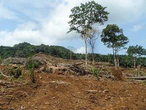
Loss of forest.
This project is focused on researching forest degradation risks and exploring vulnerability by identifying vulnerable areas and forces that are driving forest degradation. Apart from creating degradation map, the most important outcome of this work will be the visualisation of the (geo)ecological vulnerability respectively resilience that will gradually show which areas are more vulnerable toward human influences and which are more resilient.
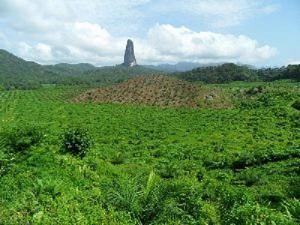
Oil plantation.
The main activities during the field survey will be (1) GPS-based ground truthing due to the verification and improvement of sat data analysis made previously and (2) mapping and documentation of degraded areas/forms.
Degraded hills – exposed to erosion.
1): I will document the current Land Use Land Cover (LULC) state (e.g. vegetation type, cropland type, bare soil, fallow lands, forests etc.) and geoecological specifications (like geomorphology, geology, soil, altitude and landscape type,) of previously chosen areas. Additional information about precipitation, climate type and typical floral and faunal species will be also ascertained.
2): I will observe degraded areas and forms of landscape. The current degradation will be distinguished and documented (description of the environmental vicinity: vegetation and soil; geomorphology and geology; measurement, positioning and photography) as well. Categorisation is necessary to obtain the spectrum of degradation forms (what kind of, how often and where they occur). This will allow me to make correlations between degradation risks and degraded areas.
I will be working in close collaboration with Direcção Geral do Ambiente (Ministério das Obras Públicas e Recursos Naturais) and Parque Natural Obô de São Tomé letting them participate in my field surveys and transferring knowledge about measuring and evaluating degradation and vulnerability.
The outcomes of this project will be made available to the government of São Tomé and to other stakeholders and will serve as source of information for further national strategic papers to ensure conservation of São Tomé’s biodiversity and improved land management.