Armen Asryan
The contribution of this project will be obtaining measurable, factual and scientific data that provides an objective view on the problem. In the short-term, the project results will contribute to the increase of public awareness on the problem of deforestation in Armenia.
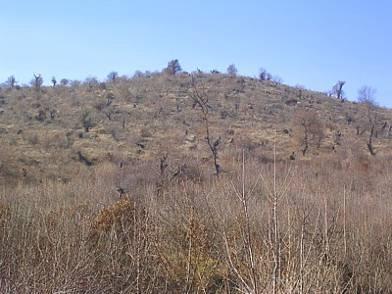
Hill slopes to the south of and immediately adjacent to Vanadzor city. Once being covered by a rich forest cover they are now a home to bare trunks.
The “Deforestation – View From the Space” Project seeks to identify the extent of deforestation in the north-eastern regions of Armenia and prepare an illustrated publication that will be used by the Armenian non-governmental and international organisations for formation of policies and programmes to combat deforestation in the country. The findings of this project will also be used as a public awareness tool by the above mentioned stakeholders. The objectives of the project include acquisition and processing of satellite imagery and land cover classification for the period of 1980s-2005. The project has a substantial fieldwork element for identification of vegetation types and their spectral characteristics on the ground. Modern remote sensing and image classification technologies are used to reveal and visualise the mass deforestation that has taken place over the period from late 1980s to this date.
The motivation for the project has originated due to understanding of the critical state of the Armenian forests coupled with the opportunity to apply the available expertise in remote sensing technologies. According to the information provided by the Armenia Tree Project, around 25% of Armenia was covered with forests at the turn of the 20th century. Today’s estimates indicate that only 8% of the tree coverage is left. According to the World Bank, 80% of Armenia is at risk of becoming a desert and with the current trends of deforestation, there will be no forests left by 2050.
The availability of the Landsat imagery archive for over 30 years presents a unique opportunity for the application of remote sensing and image classification for not only forest mapping, but also identification and tracing deforestation on a temporal and spatial scale. Vegetation, and, therefore, trees strongly reflect solar radiation in near- and mid-infrared bands of the electromagnetic spectrum. These two spectral bands, along with the visible spectrum (red-blue-green) bands are available in the Landsat imagery and allow accurate mapping of land cover.
The contribution of this project will be obtaining measurable, factual and scientific data that provides an objective view on the problem. In the short-term, the project results will contribute to the increase of public awareness on the problem of deforestation in Armenia. This will be achieved through dissemination of project results. In the long-term, the results will contribute to the formulation of policies and programmes for combating deforestation serving as an unbiased visualisation of the problem. In addition, the findings will be used for environmental education and community development by both the Armenia Tree Project and other organisations and will aid to attract further support for their programmes.
Apart from the key investigator the team includes Forestry and Remote Sensing Experts, who provide expertise in their respective fields:
The Armenia Tree Project NGO, the leading non-governmental agency involved in combating deforestation in Armenia contributes the information base developed for the last 10 years as well as their forestry expertise. In addition, the Armenia Tree Project NGO, as the main beneficiary of the proposed project, will play an instrumental role for the wide dissemination of the project results.
The Kingston University, School of Earth Sciences and Geography (ESG) represented by Dr. Michael Smith, senior lecturer and remote sensing expert, bring in ad hoc professional advice on specific aspects of remote sensing and image classification as required in the course of the project.