Phuntsho Wangdi
The project aims to study the occupancy of Tigers along with habitat zonation of other mammal species. Project further aims towards gaining the public trust in conservation of Tigers through social awareness.
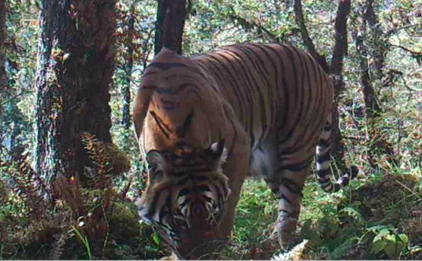
Tiger (Female).
Tigers (Panthera tigris tigris) are the globally threatened species as per IUCN Red list status and a species of great conservation importance. The project therefore aims to study the occupancy of Tigers along with its habitat zonation and other mammal species.
The study area is located in the northern region of the Paro Dzongkhag/District which is home to this majestic Tiger and also vast range of mammal’s species. The study area ranges from 2200 m to 4971 m above the sea level and lies in between the 89°27'34.66"E and 89°19'39.20"E longitudes and 27°27'39.99"N and 27°34'42.01"N latitudes.
Camera trapping and sign survey methods will be adopted for the yearlong study. The Camera traps will be installed for 7 months with twice a month monitoring. The camera trap data will be downloaded and managed twice a month during the monitoring. Sampling design will be carried out with r-statistic and ARC-GIS 9.3 software. The study areas will be divided into 34 survey girds, each measuring 5 km x 5 km with random selection of 50% of the total grids. In each grid a cluster of sampling points will also be laid randomly after every month. The team will visit the point based on GPS coordinates. Sign survey will include the presence or absence of scats, animal’s trails, scratch marks, depredation sites, water holes and high number of prey evidences. Best location with high probability to detect tigers will be selected for camera trapping.
The survey will generate habitat occupancy status of the globally threatened royal Bengal Tiger as well as other prey species under our district. By combining camera trap recordings, GPS points of signs and evidences collected from the field and history of tiger presence from the local people a tiger habitat zonation map will be generated. The generation of the habitat map will benefit our office in streamlining and focusing anti-poaching activities in the future.
Since our local communities share the tiger habitat for use of forest resources there is a continuous conflict between humans and wild animals. Therefore, this project is expected to pave a way for participatory approach for conservation of such critically endangered animals in the near future.