Article featuring the project.
Ejigu Alemayehu Worku
Other projects
10 Mar 2017
Conservation and Behavioural Ecology of the Endangered Mountain Nyala (Tragelaphus buxtoni) in the Arsi Mountains, Ethiopia
28 Jul 2022
Land Use Land Cover Changes and Ecosystem Services in the Southeast Highlands of Ethiopia
This project aims to understand the distribution pattern, population estimate and habitat suitability map of the endangered mountain nyala (Tragelaphus buxtoni) in the Arsi mountains, Ethiopia
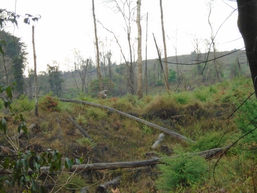
The mountain nyala, Tragelaphus buxtoni, is an endangered antelope endemic to the Ethiopian highlands. The current distribution of the species is limited to Bale and Arsi mountains. While the basic behavioral ecology of the species was studied in the Bale Mountains, little is known about the ecology and distribution pattern of the species in Arsi mountains. The current population estimates of mountain nyala in the Arsi mountains are highly tentative and are based on ad hoc observation and second hand reports. In this study I aim to determine the distribution pattern, population estimate and potential suitable habitat that needs to be prioritized the conservation of mountain nyala in the face of increasing human and livestock pressure in the region.
The distribution pattern of mountain nyala will be carried out based on extensive survey in the possible habitats (Habitats which is not yet fully influenced by human settlement and agriculture which will be identified from 2m resolution image). Once the majour mountain nyala populations are identified and their core areas is delineated, the population estimate will be carried out based on pellet count on random plots. The population size of mountain nyala in each of the core areas will be determined by using the defecation and degradation rate of the pellet samples counted in each of the core mountain nyala localities. Mountain nyala is a shy and lived in a dense habitat and other population estimation methods based on visual contact are difficult to implement. I will develop the habitat suitability map that needs to be prioritized for conservation effort by using mountain nyala presence (assessed by pellet count) in relation to land cover types (including different vegetation zones and human influenced areas), slope, elevation and distance from majour human settlements. Land cover map and distance from human settlement will be prepared from 2m resolution satellite SPOT image by using ERDAS imagine software and Arc GIS. Values of Elevation and slope will be derived from 90m Digital Elevation Model.
The result of this project will be employed in prioritizing areas requiring protection for mountain nyala population, thereby supporting management and future conservation. This research will also provide useful background information for the conservation managers and policy makers including Ethiopian Wildlife Conservation Authority and other conservation organizations to plan effective conservation measures to save mountain nyala.