Demelash Alem Ayana
Aim of the project: This research project will document information on plant species composition, land use/cover change, carbon sequestration potential and the soil seed bank of Lake Tana and surrounding vegetation.
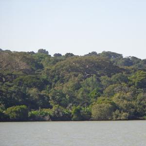
Ethiopian forests have been devastated because of high human pressure as agriculture and only remnant forests are found in some areas. One of these areas harbouring remnant forest resources are Islands of Lake Tana and its surrounding.
Aim of the project: This research project will document information on plant species composition, land use/cover change, carbon sequestration potential and the soil seed bank of Lake Tana and surrounding vegetation.
Systematic sampling method will be used (Kent and Coker, 1992) to collect vegetation and environmental data. Plots of 30 x 30 m will be established to collect data for larger trees (DBH ≥ 2.5 cm). Within the main plot, subplots of 5 m x 5 m and 1mx1m will be established for plants with a DBH of <2.5 cm and forest floor respectively. Plant specimens will be collected and brought to the National Herbarium (ETH) for identification.
An appropriate allometric model will be selected for Above Ground Biomass (AGB) Estimation for carbon study. To calculate the total biomass and total carbon stock in each plot and then the covert to per hectare basis (using a conversion factor), the total biomass and carbon stock will be summed up. The biomass stock density of a sampling plot will be multiplied with carbon fraction of 0.50 to determine the carbon stock. Pearson et al. (2005) will be used to determine the carbon stock in litter and dead wood. The Below Ground Biomass (BGB) will be estimated from AGB. Soil samples will be taken after collecting litter samples from the soil surface. Composition, density, and vertical distribution of viable soil seeds in the soil will be assessed from three soil layers (0-3 cm, 3-6 cm, and 6-9 cm) (Dalling et al., 1997; 1998).
Multitemporal Landsat images will be used to produce land cover maps. Land use/Land cover for the years will be detected from Geo-referenced, radiometrically calibrated and ortho-rectified images. The bands will be coupled with ERDAS Imagine and the images will be classified by means of multi-resolution segmentation to get regions in the image that belonged to the same spectral class. The resulting clusters and polygons will be labelled according to their texture, colour, and status (Martınez et al., 2009). This will be followed by knowledge based or supervised classification after verifying by ground control points or ground truthing. Finally, temporal rates of land cover change for each habitat types will be calculated based on the following equation (Long et al., 2007; Martınez et al., 2009).
Statistical analysis will be done with appropriate software.